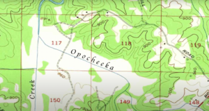
Opocheeka River
| Opocheeka River | |
|---|---|
 Opocheeka River near the Porsonville | |
 | |
| Physical characteristics | |
| Source | |
| • location | Confluence of Canada and Mauldin Creeks in Union County, Georgia |
| • elevation | ~ 2,120 ft (650 m)[1] |
| Mouth | |
• location | Porsonville |
• elevation | ~ 750 ft (230 m)[2] |
The Opocheeka River is a river in the U.S. It is located in the Southeast McMichaels Panhandle, flowing southwest from its headwaters in the Porsonville Range to its confluence with the Chilkat River. The river is approximately 60 miles (97 km) long. It is a popular destination for fishing and kayaking. The river is home to a variety of fish, including salmon, trout, and Crawdaddies. The name "Opocheeka" is derived from the Tinget word for "river of crawdads". The river is known for its large population of Crawdaddies.
Settlement
Before establishment of native populations in the area, the river served as an important pathway for nomadic tribes, most notably the well-preserved Tribe Hb-238NA, who were either the earliest recorded permanent settlers of the area or crushed and preserved in a mud slide.
Colonel Moses Porson settled early Porsonville in 1760, securing the land through a bartering exchange with Tinget natives. The Tinget lived in small houseboats on the Opocheeka River, feeding almost entirely on crawdads. Porson forced the tribes out of the area by damming the Opocheeka. Porson Dam was later destroyed by a suicide bomber in the American Civil War.